What we learned from the invasion
There is no disputing that the Russian invasion of Ukraine and the ongoing war present an excellent example of the importance of continuous and accurate intelligence gathering. It is clear from a report published by SpaceKnow just days before the invasion that satellite imagery played a key role in monitoring the Russian troops’ movements near the Ukrainian border – perhaps a result of a lack of available data. Today, analysts working in defense and intelligence face the following difficulties:
- Maintaining situational awareness on a region-size or larger scale without constraints from:
- Unfavorable weather conditions
- Coverage capacity of sensors
- Missing intelligence about areas of interest
- Ability to discover context and connections between events within a large number of locations over a long time period
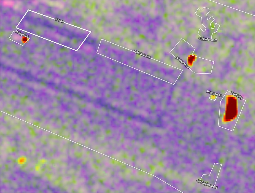
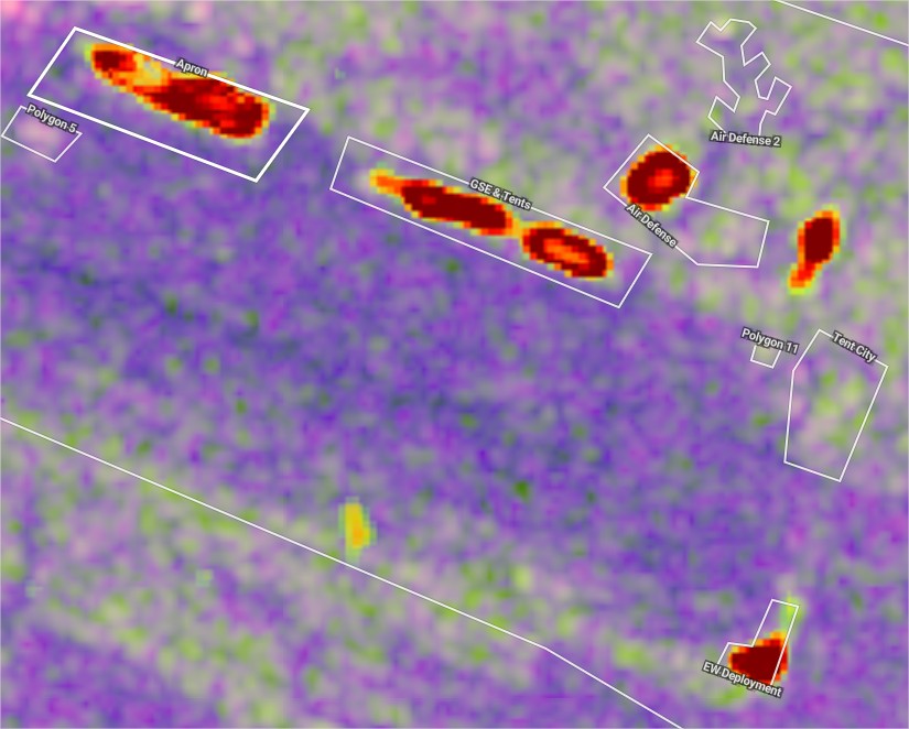
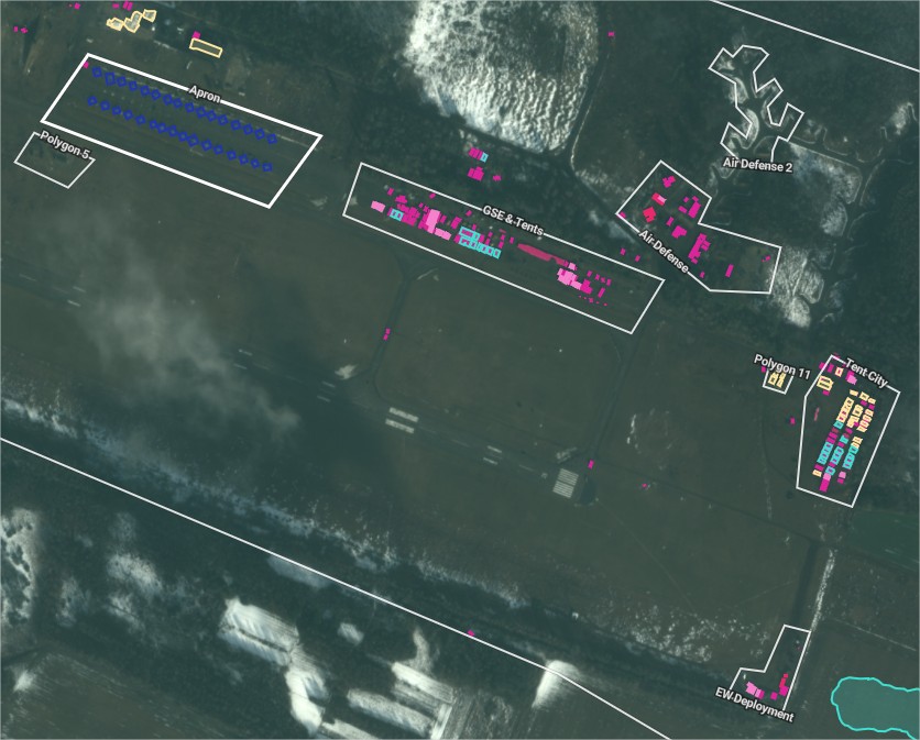
Knowing that there are tanks and air defense systems fully deployed in large numbers at an abandoned or previously unknown location is helpful. However, the system must be able to notify the analysts of the arrival of the very first pieces of equipment so that there is an actual response time available to the decision-makers. The system must also be able to highlight locations where it has previously spotted the same equipment (either on the move or at an army base, where it is now missing).
Due to the large amounts of data, numerous locations, and particularly the need for quick insights, defense and intelligence-related satellite monitoring is best addressed with automation and machine learning. Human analysts would be quickly overwhelmed on their own. SpaceKnow is continuously enhancing its defense and intelligence-related satellite monitoring product in response to these challenges.
The value of precise classification
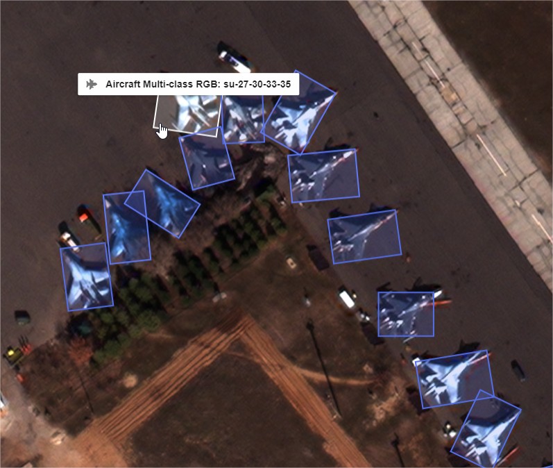
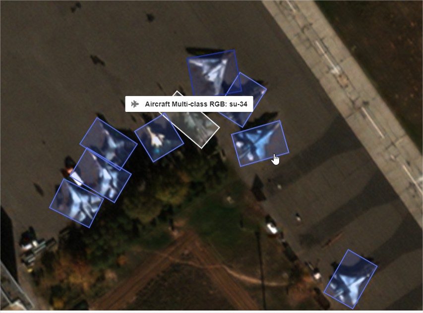
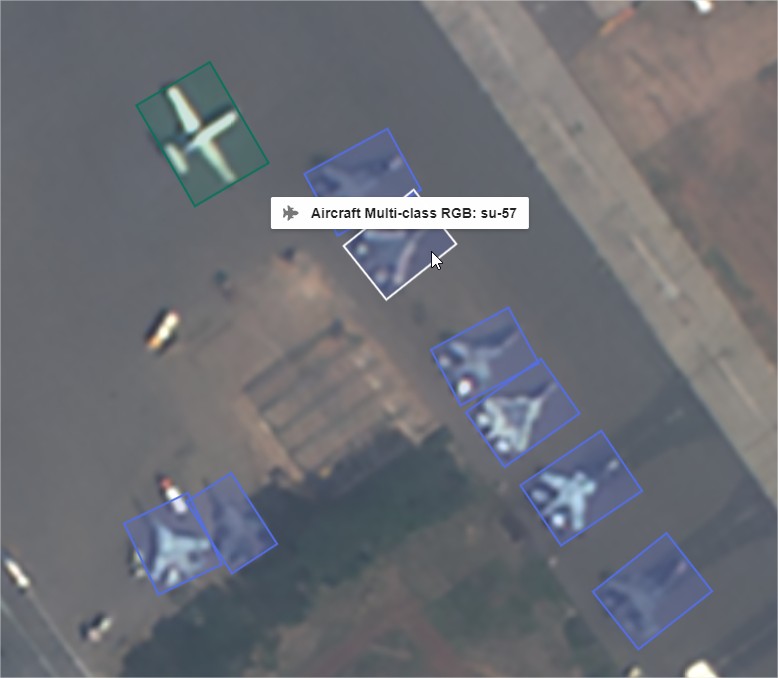
Neural networks’ capability to precisely classify military equipment relies primarily on the quality and quantity of data, and as such is currently dependent upon the number of satellites in a constellation, their revisit rate, and sensor quality. It is possible to do a lot of work on engineering, fine-tuning, and intelligent system and product design to enhance and assist the process. While high precision is still extremely important in the field of defense and intelligence imagery intelligence (IMINT), human analysts are still ahead due to their strong contextual knowledge, which they can apply during the analytical process. The objective of machine learning applications is not to replace human analysts but to enhance and assist the overall process (also known as human-in-the-loop), particularly when dealing with large quantities of data. It is worth mentioning, that SpaceKnow is always working to improve its algorithmic capabilities—expanding the number of algorithms, broadening the classification capabilities, and creating a true provider agnostic environment. With automation and permanent monitoring being the key priorities over the past year.
Current challenges
SpaceKnow always strives to deliver the most advanced solutions with high added value and is committed to exploring new ways to significantly improve and enhance the users’ experience. One of the main goals is to allow customers to focus on the unknown, a perfect use case for automation and machine learning. The ever-developing and fluid security situation around the globe requires multiple intelligence assets from diverse domains (such as SIGINT, ELINT, and HUMINT). Fusing all gathered data and information into actionable insights to maintain situational awareness at the highest level is essential for users.
Even smaller nations are able to benefit from satellite data thanks to the availability of commercial satellite imagery. A number of providers of both optical and SAR imagery are necessary to ensure that any location can be monitored at any time. SpaceKnow proudly performs such activities on behalf of those with limited capabilities – the team continually adds more satellites to the platform so that the proprietary algorithms can analyze data in provider-agnostic models. This solution saves SpaceKnow’s clients time and money. Users select where, when, and what to monitor, and SpaceKnow takes care of everything else. At the same time, this is where things get complex, and sometimes it can be a little challenging to grasp the true advantages of utilizing satellite imagery and leveraging automation.
SpaceKnow’s solutions
The SpaceKnow platform and its frontend analytics interface, named Guardian, perfectly combine the power of cloud computing with the latest iterations of proprietary algorithms, a diverse selection of satellite imagery providers, and a clean, easy-to-use interface. SpaceKnow can deliver this as a pure cloud-based service or as an on-premise solution running either on a private cloud or a dedicated hardware setup.
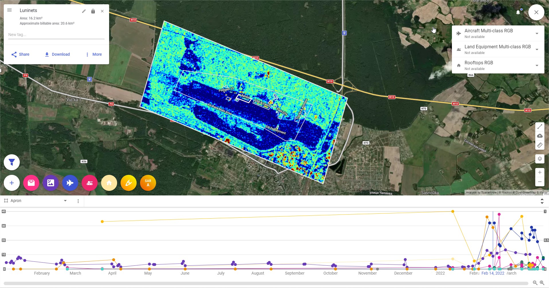
The advantages of using Guardian are numerous, but the most important one is that it can deliver critical information, data, and insights in a straightforward format. Users may establish any number of areas of interest of any size, ranging from small local spots to large regions covering thousands of square kilometers. The system can perform historical analysis to provide the user with basic parameters such as average change detection and basic parameters so that thresholds for monitoring can be set up accordingly. This is significant because the user can better evaluate the degree of change or number of equipment deployed based on historical data. On both sides of the spectrum, the user can determine what is normal and what is not and can act accordingly.
While most air bases can usually maintain 10 fighter aircraft on the tarmac, the sudden deployment of an additional 10 fighter aircraft, bombers, helicopters, and air defense systems suggests something interesting may be on the horizon – either an exercise, show of power, or plain aggression. Based on the importance of the base, the monitoring can be done utilizing medium or high-resolution satellite data. In most cases, utilizing low-resolution SAR data on regions of interest and setting up thresholds for change detection, will prove sufficient – once there is an increase in positive or negative change, the user can decide whether to cue in high-resolution imagery or request confirmation from other intel sources.
Guardian is a very precise and expert-level solution that provides users with a broad range of tools in order to set up complex and high-added value monitoring. SpaceKnow can provide a simplified version of the monitoring capability so that anyone who is not sure how to exactly implement and utilize something with such complexity can rely on SpaceKnow experts and a scalable interface that will not overwhelm users with too many options.
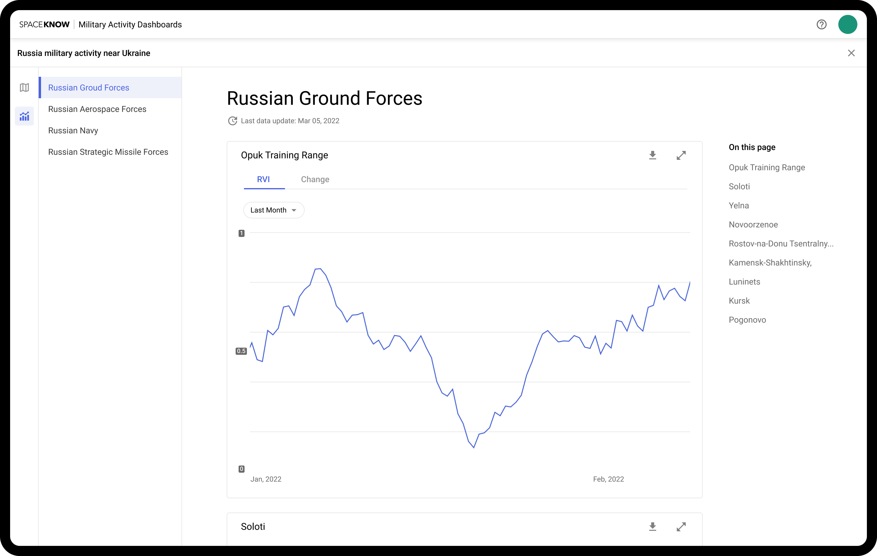
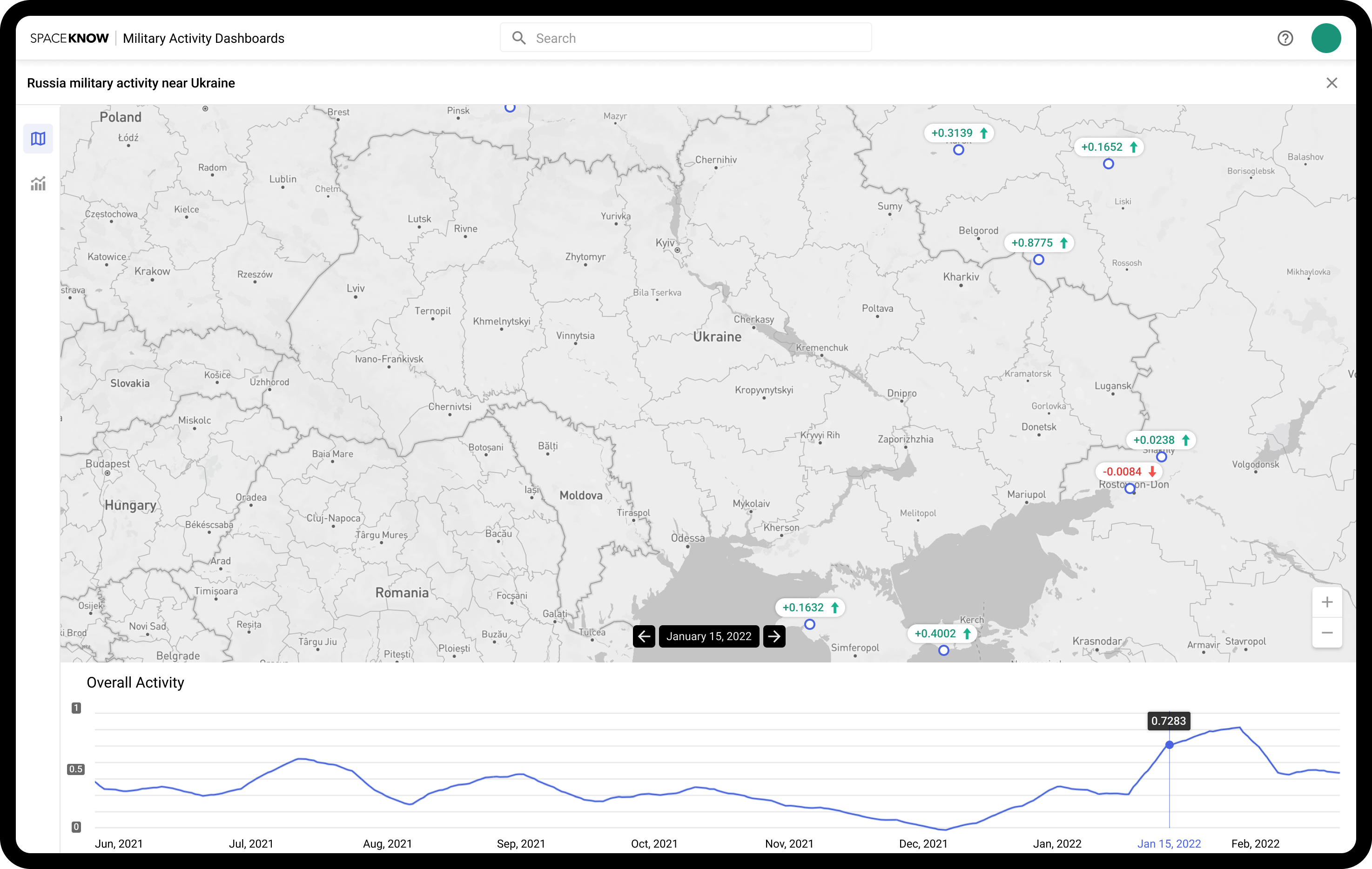
Military Activity Index
A dedicated dashboard providing continuous automatic time series for military activities in specific countries, their armed forces, specific branches, and different theaters will be deployed in the next phase. The user can view a comprehensive time series of Russian Armed Forces military activity at hundreds of air, ground, and naval bases, but they can also narrow down their focus to the Baltic Fleet Command or select diverse options based on interest. The system is designed such that one can directly go from the time series to Guardian’s interface and order high-resolution imagery or search the archives for the most recent data in order to assess the indicated development in higher detail. All within one interface, with intuitive visual design and helpful tooltips as well as dedicated onboarding sessions and tutorials.

Conclusion
To summarize, in addition to cutting-edge high precision detection and classification capability, SpaceKnow currently deploys solutions that enable the users to:
- Constantly monitor thousands of locations in a 24/7 regime with affordable low, medium and high-resolution data
- Set alerts and receive notifications about increased activity, sudden changes, and departure or arrival of specific equipment
- Monitor military activity of selected countries in the form of indices
Contact the SpaceKnow team to discuss how SpaceKnow’s approach to automation can improve your intelligence cycle by enhancing your analyst’s capabilities.
Written by Jakub Broz on behalf of SpaceKnow, Inc.