Introduction
In cooperation with the European Space Agency (ESA), SpaceKnow is developing a cutting-edge solution to automatically detect ships on high-resolution SAR satellite imagery. Project SEA-SPARK is well underway and the team is thrilled to provide some context and elaborate on its importance.
Why now?
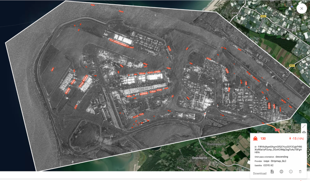
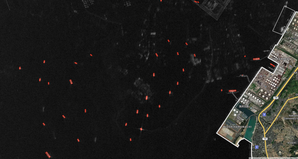
Synthetic Aperture Radar (SAR) satellite imagery is gaining traction in the Earth Observation market, above all due to its ability to capture images regardless of atmospheric conditions. Optical satellite imagery, the type of satellite imagery you might see on the news, has the inherent weakness of being dependent on atmospheric conditions. For example, let’s say a certain region is particularly cloudy for a week, it’s very possible that all optical satellite imagery taken over that region may not be very useful due to cloud cover. The ability to see through clouds (and at night) is a key advantage that makes SAR data very attractive to its users. (For more on the SAR satellite revolution, Scott Manley does a great job explaining the trend with his youtube video, watch it here.)
Rapidly growing constellations operated by commercial providers like ICEYE or Capella are generating immense amounts of data every day. The analysis of SAR imagery, however, is still a challenging task. To address this, SpaceKnow launched project SEA-SPARK, supported by ESA, aiming to improve automated ship detection on SAR imagery.
Why ships?
Since most of our planet’s surface is covered by water, it is very costly to monitor those vast areas by earth-based sensors or by human analysis. In particular, ships without AIS (Automatic Identification System), referred to as ‘Dark Ships’ because of their common engagement in illegal activities, are hard to detect by traditional means. That’s where SpaceKnow’s scalable SAR Satellite Imagery analysis comes in as an invaluable resource.
The problem of ship detection on SAR data is exemplified by the worldwide competition xView3: Dark Vessels, supported by the US government organizations. The organizers said: “the barriers to improving analytical capabilities have proven to be substantial. There are no SAR datasets with validated ground truth detections available for academic, industrial, and open source communities to tackle the problem of detecting and classifying the activity of vessels at sea”. Unlike xView (which used free low-resolution SAR imagery), SpaceKnow is building its solution with high-resolution SAR data, enabling higher performance of the algorithms, and detections of smaller boats.
Why SpaceKnow?
Over the last nine years, SpaceKnow has built extensive expertise in the automated analysis of SAR data, often referred to as a ‘preferred partner’ when it comes to running algorithms (for example: car counting, change detection, vegetation encroachment, and several others). The company already has algorithms for ship detection on SAR. The project SEA-SPARK, however, aims to develop a more robust solution by placing emphasis on hard examples where standard solutions usually fail.
Goals of the project
The SEA-SPARK project aims to design, implement and experimentally evaluate deep learning-based advanced algorithms for high-resolution SAR satellite imagery. The algorithms look to detect and classify maritime vessels ranging from small transport and commercial vessels to large tankers and military ships. SpaceKnow will contribute by pushing the boundaries of current state-of-the-art technology by improving performance and creating a robust and trustworthy solution. Successful completion of the project would enable SpaceKnow to deliver better insights to customers reliant on precise and persistent maritime monitoring, vessel detection, and classification.
Users and their needs
Users can include:
- Port Authorities
- Maritime Traffic Management
- Border Authorities
- Intelligence Agencies
- Fishing Authorities
Needs that are addressed:
- Unbiased and complete insight into maritime traffic
- Detection of ships with disabled AIS
- Detection of ships inside restricted areas
Key Takeaways
- In collaboration with ESA, SpaceKnow leverages its expertise in satellite analytics to tackle pertinent challenges and problems in the maritime environment using satellite and data processing technologies.
- SEA-SPARK aims to push the borders of what is possible in terms of ship detection on high-resolution SAR satellite imagery.
- SpaceKnow continues to innovate and further develop its competencies to service its growing client base of banks, institutions, investors, and governments with accurate and timely data derived from satellite imagery.
- SpaceKnow continues to lead and gain recognition for its technology and methodologies in the domain of satellite data analytics.