Satellite monitoring for defense and intelligence

Transponders go dark and GPS signals get spoofed. Satellite imagery shows what is actually on the ground.

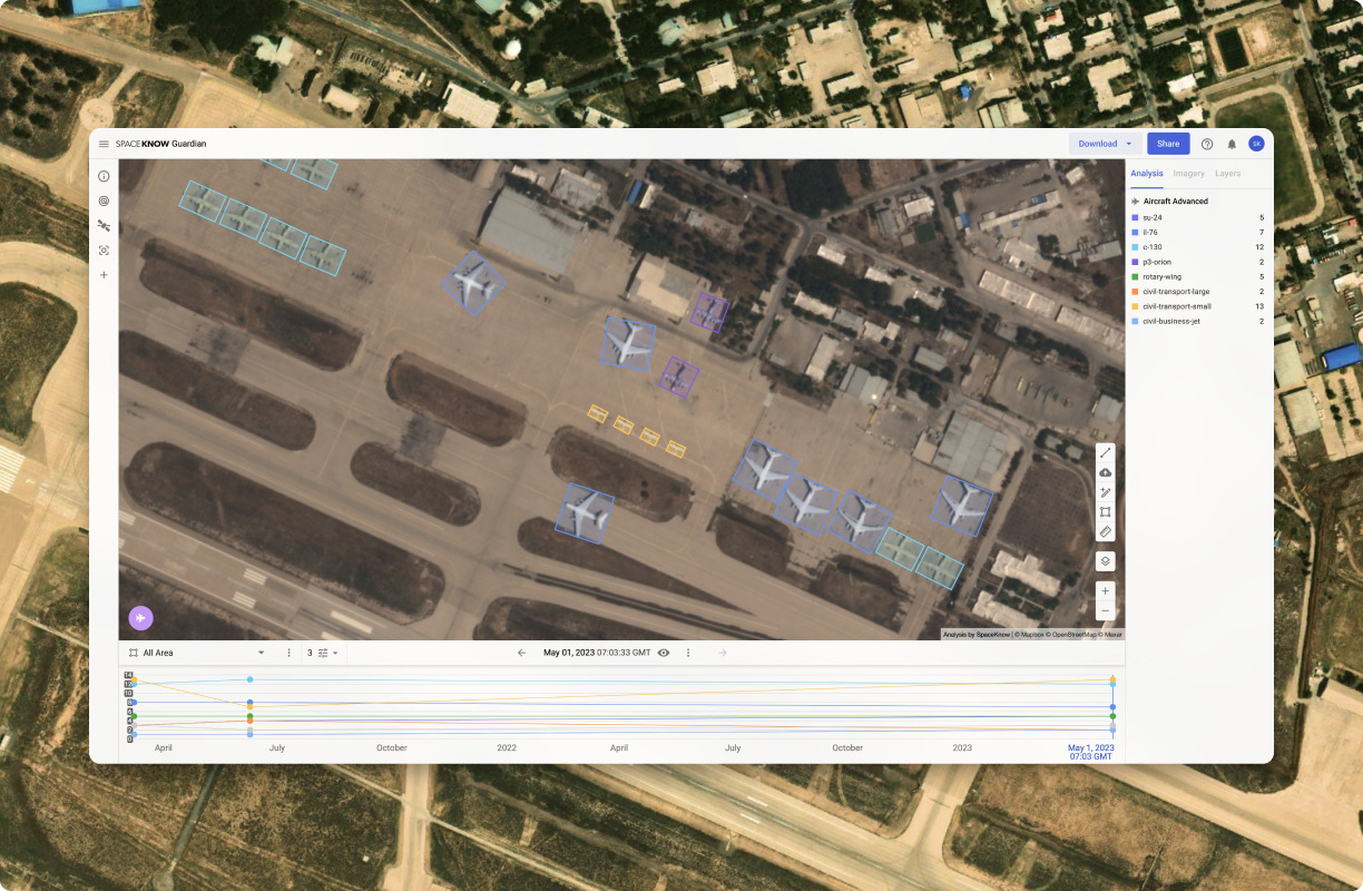
Aircraft detection in SpaceKnow Guardian

SpaceKnow Guardian® is imagery intelligence (IMINT) software for defense and intelligence organizations, powered by proprietary algorithms.

It detects and classifies ships, aircraft and land equipment in optical and SAR satellite imagery of any resolution, measures change at military sites and monitors maritime and border areas continuously.

Mission areas

Maritime domain awareness

Detect and count vessels across wide sea areas, independent of what their transponders report.

Shadow fleet and sanctioned vessels

Monitor ports, anchorages and ship-to-ship transfer areas used by vessels that switch off AIS.

Military site monitoring

Follow aircraft and equipment at airbases and naval bases over weeks and months, until a pattern of life appears.

Battle damage assessment

Compare imagery from before and after a strike and document visible damage with coordinates and dates.

Critical infrastructure

Watch ports, energy sites, pipelines and cable landing points for change and unusual activity.

Border and coastal surveillance

Survey wide border and coastal areas daily on affordable imagery and order high resolution where activity appears.

Thousands of sites. One alert when it matters.

Guardian monitors thousands of areas worldwide on widely available mid-resolution imagery and flags change automatically. Your analysts open only the sites where something changed and order high resolution for a closer look.

Down to the specific model.

Guardian detects ships, aircraft and land equipment and classifies them down to a specific model where imagery resolution allows.

The algorithms were developed with the European Space Agency and satellite imagery providers.

Radar sees through cloud and darkness.

Guardian combines optical imagery with synthetic aperture radar (SAR). Radar images the ground at night and through cloud, so monitoring continues when optical sensors are blind. When weather or orbit limits one provider, the same analysis continues on another.

Analytical independence across any sensor, any provider, any orbit.

Features built for imagery analysts

Change detection

Guardian compares two or more images of the same place and highlights what changed: new equipment, moved vessels, fresh construction, damage. Repeated over time, the comparison reveals a site’s pattern of life.

Automated monitoring and alerts

Guardian watches any number of sites, detects objects, tracks change, sends regular activity reports and alerts your team as soon as hostile activity appears. Monitor → Detect → Track → Alert.

Tip & Cue surveillance

Survey wide areas on low-cost or free imagery. When Guardian flags activity, order high-resolution imagery for that spot only, so you pay for detail where something happened.

An interface built for analysts

Charts, a military equipment directory and filters sit next to the imagery. Ingest and filter imagery, combine algorithms and visualize results in one place.


Frequently asked questions

What is imagery intelligence (IMINT)?

Imagery intelligence is information derived from analyzing images of the Earth’s surface, including satellite imagery. SpaceKnow Guardian® automates the first pass of that analysis: it detects and classifies objects, measures change and flags activity for analysts to review.

Can Guardian detect vessels that switch off AIS?

Guardian detects vessels in optical and SAR imagery whether or not they transmit AIS. Comparing detections with reported positions shows vessels that are not where their transponder says, or not broadcasting at all.

Does Guardian work at night and through clouds?

Yes. Synthetic aperture radar (SAR) images the ground at night and through cloud. Guardian runs its analysis on radar and optical imagery, so monitoring continues in any weather.

Why use Guardian instead of buying imagery from one satellite operator?

An operator sells access to its own satellites. Guardian works across multiple independent optical and radar providers in one analytical environment, so your analysis does not depend on any single constellation.

Can Guardian analyze imagery from our own national satellites?

Guardian can ingest imagery your organization already has access to and run the same algorithms on it alongside commercial sources.

How do analysts verify a detection?

Every detection is shown on the source image with coordinates and acquisition date. Analysts inspect it, confirm or reject it and annotate it before it goes into a report.

How much high-resolution imagery do we need to monitor a large area?

Far less than full coverage. Guardian watches wide areas on low-cost or free imagery and cues high-resolution imagery only where it detects activity. This method is called Tip & Cue.

Can Guardian run on-premise?

Yes. Guardian is available as a cloud service or as an on-premise deployment for classified environments.


While Europe warns that strikes on NATO territory may be staged as accidents, SpaceKnow Guardian keeps the analysis in your hands, on any satellite source available.

Radar or optical, free or high-resolution. Guardian runs the same detection models on all of it, so your read of events never depends on a single source.

Analytical independence across any sensor, any provider, any orbit.

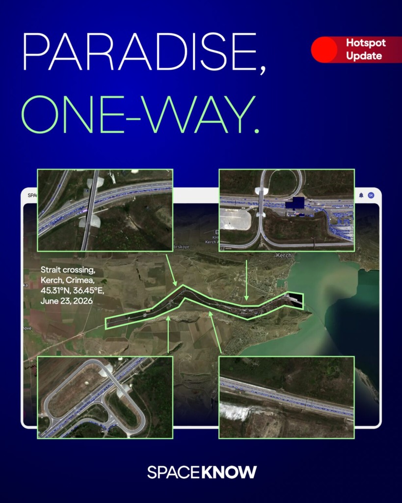
SpaceKnow Guardian captured a vehicle queue stretching roughly 7 kilometers toward the Kerch Bridge — the strategic link between Crimea and mainland Russia.

On June 23, 2026, our analysis detected around 780 civilian vehicles backed up at the strait crossing near Kerch.

The cause isn’t seasonal traffic. Fuel shortages, rolling blackouts, and a bridge that closes repeatedly for air-defense alerts have left residents waiting hours to leave. Ukrainian strikes on rail links and fuel terminals have added to the squeeze.

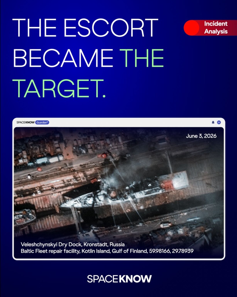
SpaceKnow Guardian captured the Kronstadt dry dock hours after the strike — independent imagery of an event still being assessed.

On June 3, 2026, Ukraine’s Unmanned Systems Forces struck the Russian corvette Boykiy at the Veleshchynskyi Dry Dock in Kronstadt — roughly 1,100 kilometers from the Ukrainian border.

The Boykiy, a Project 20380 guided-missile corvette of Russia’s Baltic Fleet, had been in repairs since February. For years, it escorted Russia’s shadow-fleet oil tankers through the Baltic.

That detail matters: the same maritime activity Guardian is built to monitor — shadow fleet movements, sanctioned vessel tracking — connects directly to this corvette’s history.

Drone footage confirmed the strike. Satellite imagery adds an independent layer: the post-strike state of the dry dock, observed from orbit, regardless of what either side reports.
Battle damage assessment is ongoing. The picture from orbit is part of how it gets verified.

Satellite imagery confirms what drone footage shows. And then keeps watching.
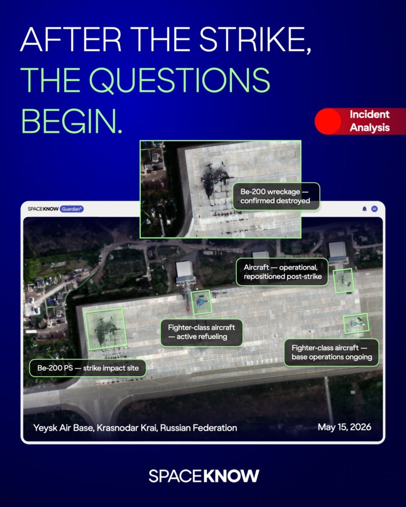
On May 15, Ukraine’s Unmanned Systems Forces destroyed a Russian Be-200 amphibious aircraft at Yeysk airbase — one of Russia’s rarest naval aviation assets, irreplaceable under current sanctions.

Drone footage confirmed the strike. Satellite imagery adds a different layer.
Post-strike imagery of Yeysk shows the Be-200 wreckage still on the apron, uncleared. Two aircraft — including what appears to be a fighter class jet actively being refueled — visible on the same ramp. Ground vehicles moving. The base is operational.

One strike. One lost asset. The base posture: unchanged.

SpaceKnow Guardian provides persistent multi-source monitoring over high-interest areas — optical and SAR, independent of what either side chooses to publish.

One airbase. Watched from orbit — before, during, and after.

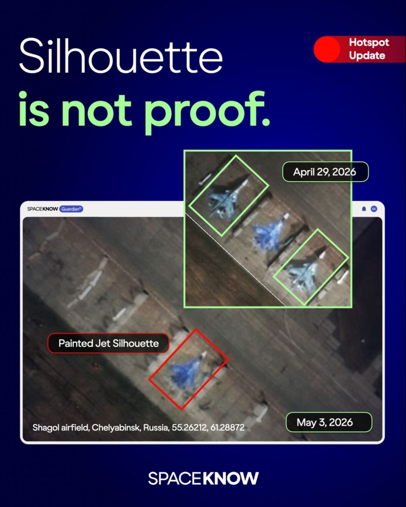
When a site is set up to mislead, SpaceKnow Guardian sees through the deception. SpaceKnow Guardian’s analysis of Russia’s Shagol airfield identified a newly added aircraft-shaped marking at the reported strike location — a painted fighter-jet silhouette consistent with a Su-34.

The airfield, located nearly 1,700 km from Ukraine’s border, was reportedly struck by Ukrainian drones, with high-value aircraft including Su-57 and Su-34 fighter jets reportedly damaged. Post-strike imagery revealed not just damage but also a possible deception indicator.

After a strike like this, defence and intelligence teams need to quickly understand the aftermath. If decoys and markings distort the assessment, they distort the decisions that follow.

Guardian helps separate actual aircraft presence from aircraft-shaped markings by comparing imagery across providers, sensors, and time. As a vendor-agnostic data fusion platform, it processes optical and SAR imagery from multiple satellite providers, 24/7, and turns site changes into reliable assessments analysts can use.
Don’t let deception shape your strategy. Build it on verified data.

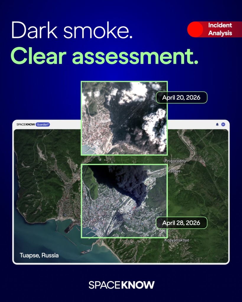
Even through the dark smoke, Guardian keeps watch.
Ukraine’s latest UAV attack on Russia’s Tuapse oil refinery caused another major fire near the Black Sea port. It was not an isolated strike.

Earlier attacks on April 16 and April 20 had already disrupted refinery operations, affected port operations, led to oil-product cleanup across the city and port, and raised environmental concerns.

By April 26, SpaceKnow imagery showed the fire had been extinguished, but the site was not back to normal. In the night of April 27–28, Ukrainian forces struck again, with reports indicating that previously untouched storage tanks caught fire.

When visibility is limited, a single report or collection source is never enough. Defence and intelligence teams need a continuously processed exploitation layer without relying on one provider’s coverage, sensor, or availability.

SpaceKnow Guardian is a vendor-agnostic data fusion platform that helps monitor contested infrastructure across regions like the Black Sea. It processes imagery from any satellite provider — optical or SAR — through 80+ proprietary algorithms, 24/7, turning multi-source satellite data into one independent operational picture.

Maintain your analytical independence, even when the picture is clouded.
SpaceKnow Guardian monitors high-risk regions 24/7, detecting events as they unfold and connecting them into actionable context.

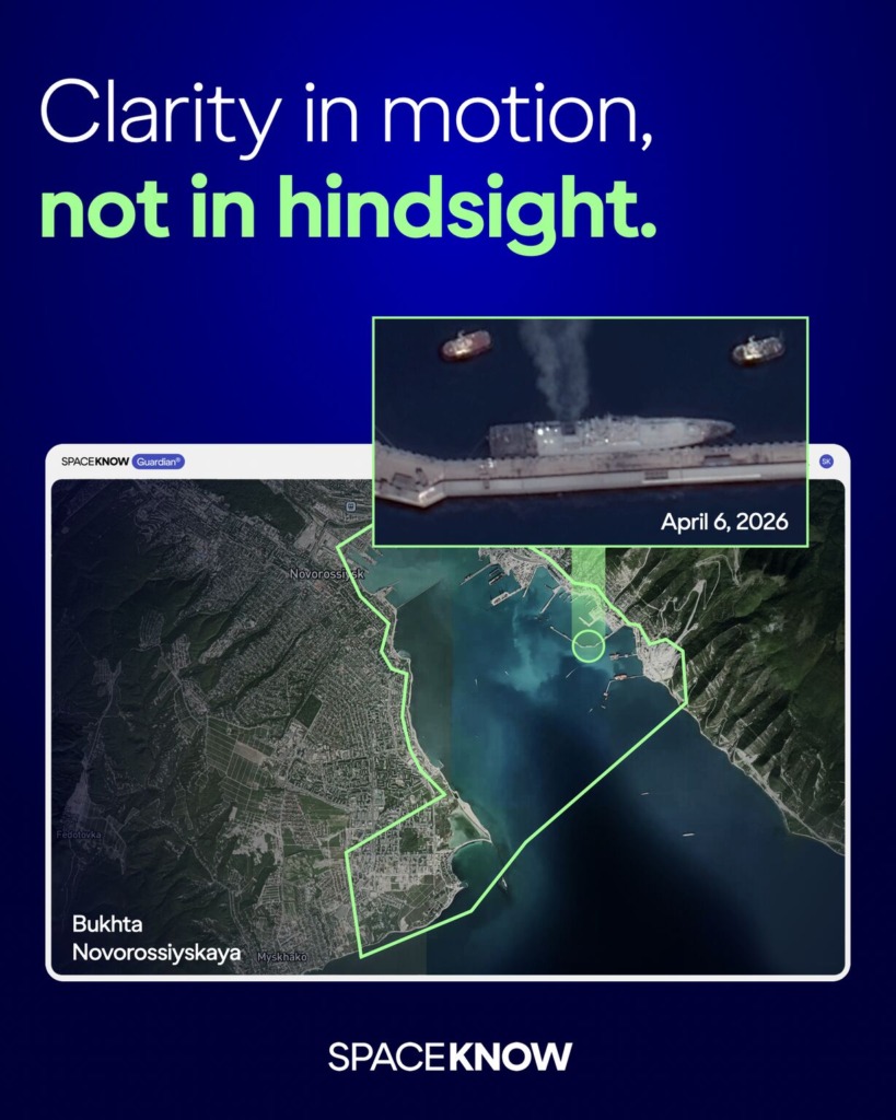
The recent Ukrainian strike on Novorossiysk shows why this approach matters. Satellite imagery confirms the UA drone strike affected Admiral Grigorovich-class frigate.

In incidents like this, no single source provides a complete picture. Information is partial, delayed, or contradictory — and manual analysis cannot keep up with the volume and speed of incoming data.

SpaceKnow Guardian operates as a vendor-agnostic, multi-source platform, combining imagery across providers to remove reliance on any single input. By processing this combined view automatically, it allows events to be verified, connected, and understood as they unfold — delivering not just data, but context, and the independence to rely on your own assessment.

Relying on a single source means missing the rest. SpaceKnow Guardian is a vendor-agnostic platform combining imagery from multiple providers, ensuring analytical independence.

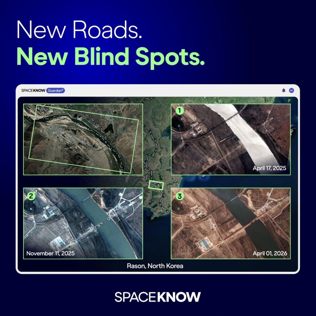
Until now, trade between Russia and North Korea has relied on maritime and rail routes, both relatively structured and easy to track. Now the two countries are building their first road bridge across the Tumen River, linking a key trade hub between North Korea, China, and Russia. 
The 1 km long, two-lane bridge is designed to handle up to 300 vehicles per day. It will enable direct transfer of oil, grain, and potentially even military equipment. Tracking such flows requires continuous monitoring, not isolated observations.

Guardian processes multi-source satellite imagery 24/7, automatically detecting changes on the ground and alerting you when new activity appears within your area of interest — with context provided alongside detection. 
No important progress goes unnoticed. Or misunderstood.
In fast-moving situations, a single source of information is not enough. SpaceKnow’s Guardian platform integrates multiple satellite sources to track events as they unfold.
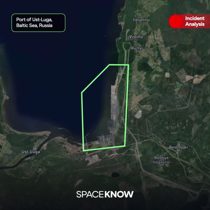
Recent satellite images of Russia’s Ust-Luga port show the effects of repeated Ukrainian drone strikes on its oil export infrastructure. Over 10 days, the site was targeted several times, with photos showing smoke, damage to storage facilities, and ongoing disruptions, including fires, smoke, and cooling of undamaged tanks with firefighting water.

Events like this highlight a crucial challenge. Infrastructure disruptions are often only partly reflected in official reports—especially when incidents happen repeatedly within a short period.

SpaceKnow’s Guardian platform processes imagery from multiple satellite providers, optical and SAR, through proprietary algorithms running 24/7. This allows you to maintain an independent, continuously updated view of events on the ground. No single source provides that.

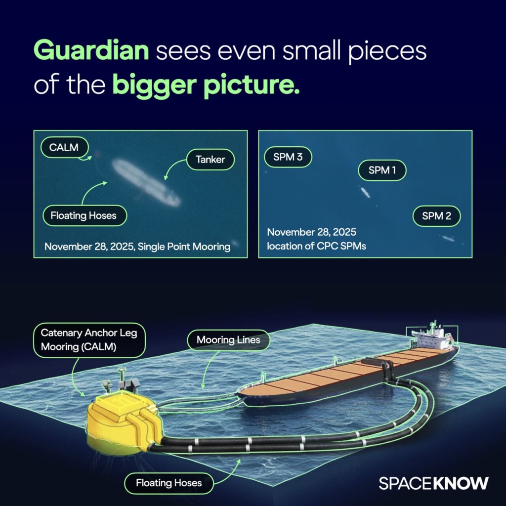
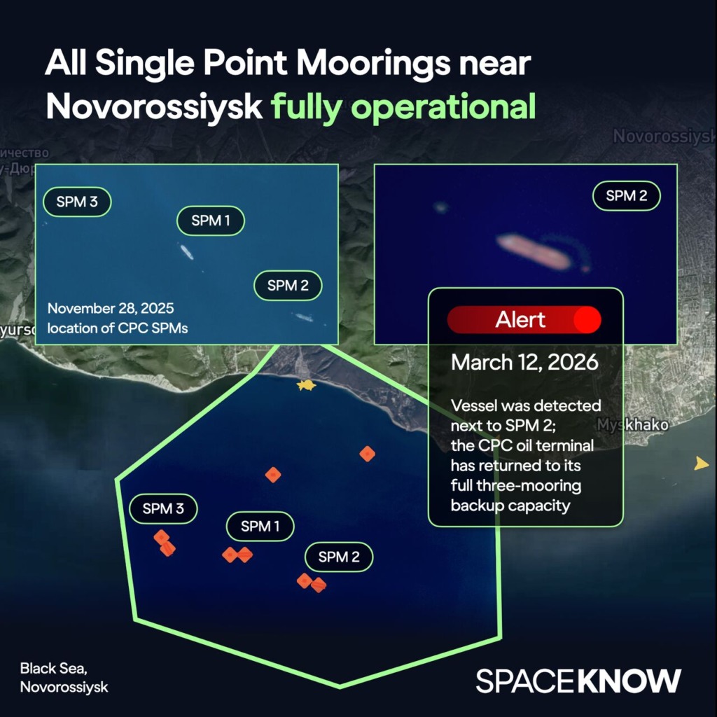
SpaceKnow Guardian satellite monitoring reveals that the Caspian Pipeline Consortium (CPC) terminal near Novorossiysk has restored operations across all three offshore oil loading buoys following a Ukrainian naval drone strike. These Single Point Moorings (SPMs) enable crude oil to be transferred directly from pipelines to tanker ships at sea.

Timeline detected by SpaceKnow Guardian:
Nov 29, 2025 — Ukrainian naval drone strike damages SPM 2. At the time of the attack, SPM 3 was already out of service due to planned maintenance, leaving CPC to operate only through SPM 1.
Jan 14, 2026 — Satellite imagery shows floating hoses next to SPM 3, indicating the mooring is being reactivated.
Jan 25, 2026 — SPM 3 returns to service, restoring the terminal’s two-mooring capacity after nearly two months of single-SPM operation.
Mar 2, 2026 — Imagery detects floating hoses next to SPM 2, suggesting repairs are nearing completion.
Mar 12, 2026 — A vessel detected at SPM 2 confirms the mooring is active again, restoring CPC’s full three-mooring capacity roughly 3.5 months after the attack.
By continuously monitoring areas of interest over time, SpaceKnow Guardian detects even subtle infrastructure changes, providing early indicators of disruption, recovery, and operational status.

Monitor Change From Above. Before It Escalates 
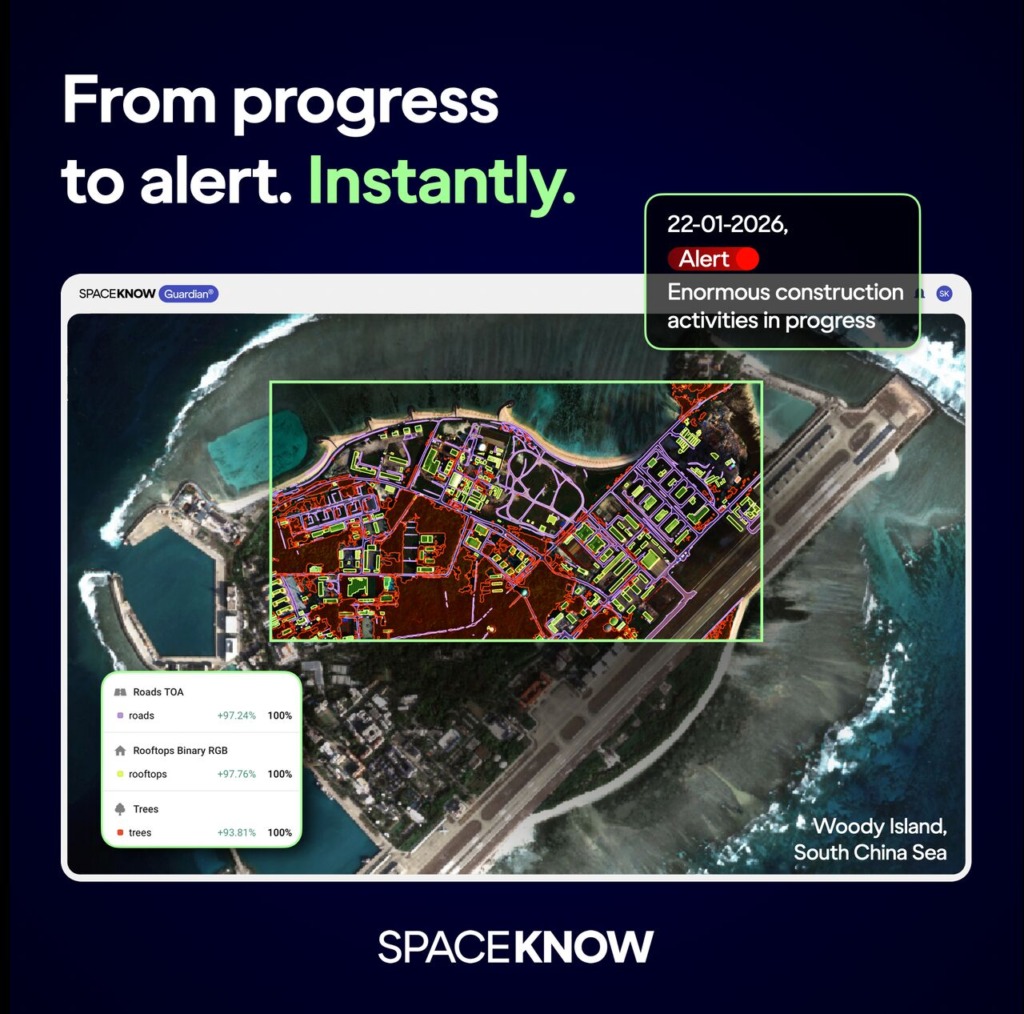
SpaceKnow Guardian monitors your selected area of interest 24/7. Construction activity, troop movements, or emerging infrastructure changes are automatically detected. Automated alerts are delivered immediately when thresholds are crossed.
In the South China Sea, Guardian has been tracking ongoing construction on Woody Island, a China-controlled outpost in the Paracel Islands. Recent imagery shows newly detected rooftops and continued construction works across the site. The island has been significantly expanded over time. It reflects a broader pattern of land reclamation and infrastructure development across the South China Sea. Across the region, reefs and small islands have been developed into strategic bases.
In strategic regions where infrastructure evolves rapidly, persistent satellite monitoring provides early visibility, giving decision-makers time to assess and act.

SpaceKnow Guardian delivers continuous construction monitoring across your area of interest. It quickly identifies expansion, new structures, and shifts in site activity as they occur. When thresholds are crossed, automated alerts inform you immediately so you can assess the situation and respond without delay.

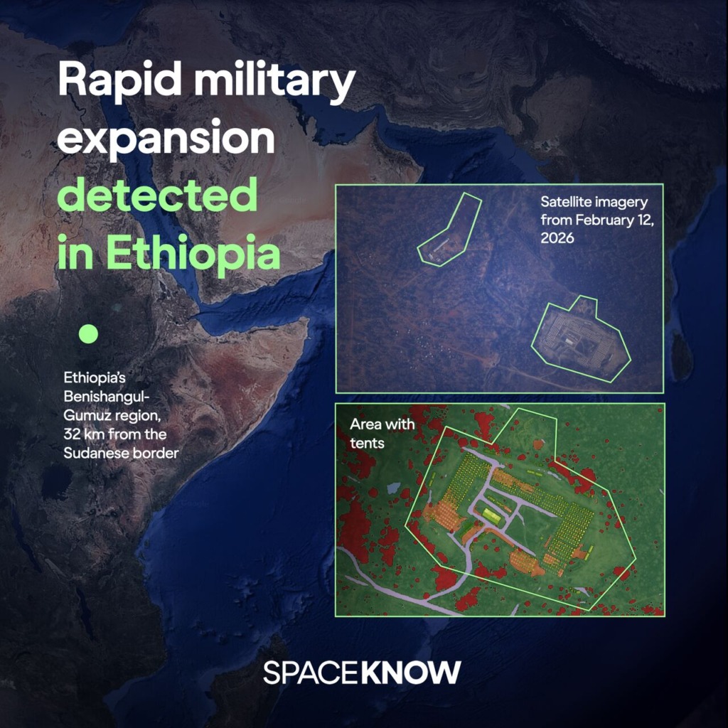
In Ethiopia’s Benishangul-Gumuz region, 32 km from the Sudanese border, Guardian has been continuously monitoring rapid construction of a secret military camp.

Development of the upper section began in April 2025 following initial land clearing. The tent and container area expanded rapidly between October 2025 and January 2026. By late 2025, hundreds of uniform tents, heavy machinery, and sustained vehicle activity were visible in satellite imagery.

January 2026 imagery shows continued expansion of the site, including additional earthworks and rows of shipping containers. According to available reporting, fighters for Sudan’s RSF are expected to be trained there. Approximately 53 km away, Asosa airport displays parallel development consistent with aviation and drone support infrastructure.

In volatile regions, accelerated construction often precedes changes in operational capacity. With 24/7 monitoring, automated change detection, and real-time alerts, Guardian detects these developments early — giving decision-makers time to assess and act.

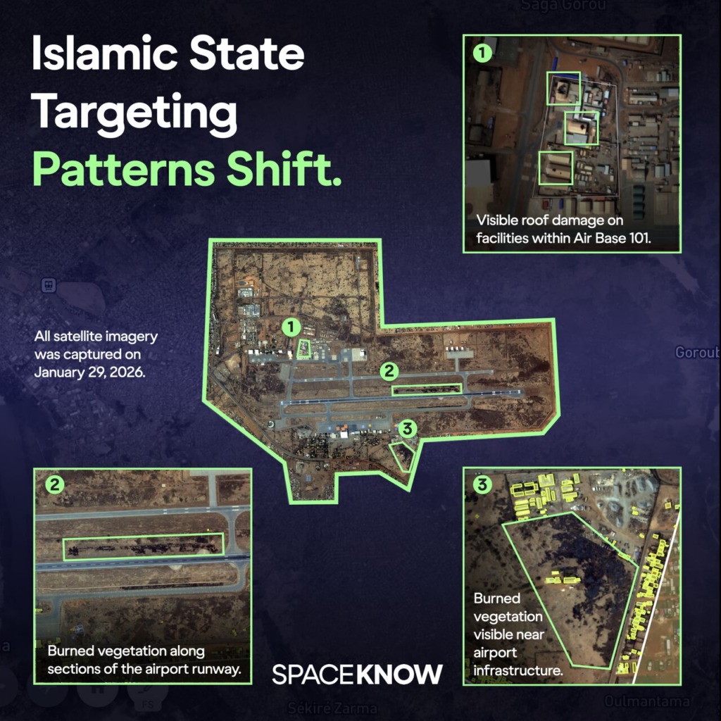
For years, IS-Sahel operations have primarily targeted rural military outposts, border convoys, and remote security infrastructure across western Niger. These incidents have occurred far from dense urban centers.

On January 29, 2026, the pattern shifted.

Heavy gunfire and explosions were reported at Diori Hamani International Airport in Niamey, co-located with Air Base 101 — a strategic aviation hub where most of Niger’s military aircraft and drones are stationed.

As competing narratives emerged, SpaceKnow Guardian turned to satellite imagery captured just hours after the attack. The imagery reveals:

Scorched vegetation along sections of the airport runway perimeter
Visible structural damage to a facility roof within Air Base 101

Physical indicators confirm localized impact within critical airport infrastructure. Despite structural damage to the facility, runway integrity appears maintained, and no widespread disruption of core airport operations is visible.

As competing narratives continue to circulate, SpaceKnow Guardian focuses on measurable change, anchoring analysis in verifiable satellite data.

On November 29, 2025, SBU launched a precise drone strike on Single Point Moorings (SPMs) near the Russian port of Novorossiysk. The attack targeted the export capacity of Caspian Pipeline Consortium (CPC), a company that runs this maritime terminal and in which Russia is the major stakeholder.
SpaceKnow Guardian monitored the whole incident using satellite imagery and its precise analytical algorithms:
On November 28, 2025, tankers were detected loading oil at SPM 1 and SPM 2, while SPM 3 appeared inactive due to maintenance.
On November 29, 2025, SPM 2 was attacked by a Ukrainian naval drone.
Imagery shows SPM 1 resumed operation one day after the attack, while confirming that the SPM 2 CALM remains afloat, with missing hoses indicating sustained damage.
While the terminal relied solely on SPM 1 for several weeks, imagery from January 14, 2026, shows floating hoses appearing next to SPM 3, indicating it may be back to service soon.
Several vessels involved in CPC oil export are identified as “dark ship candidates.”
Imagery shows no oil spillage into the sea.
Missing hoses, CALM still afloat, no oil spillage – even small details can tell a large story. With Guardian, it reads loud and clear.

Interested in:

Please select at least one option