Urbanization is a world-wide phenomenon, which has introduced benefits and challenges at the same time. It is one of the cornerstones of the post-industrial revolution era, as growing numbers of people leave rural areas to gain access to better jobs, education, services and an overall higher quality of life.
As it is often the case with society-wide paradigm changes, urbanization is outpacing our ability to deal with it. However, quality of life cannot decline with growing urban population – an increase must be achieved. Public (municipalities, state governments) and private (e.g. telecommunication providers, utilities and construction companies) institutions are responsible for managing those challenges.
In order to make informed decisions, these institutions need access to current data. Traditional data sources (for example, cadastral maps, census, ground-based observations) are delayed, time-consuming to analyze and do not provide enough information on their own. This is just as true for developed countries as it is for emerging markets.
Satellites to the Rescue
The invisible, yet mighty, leaps forward in remote sensing capabilities and machine learning continue to bring value to the table, in the form of timely insights. Modern satellite systems are diverse in revisit rates, spatial resolution and types of sensors, but the advantages over the traditional data sources are common for all. When combined with our recently expanded WRUNCTR algorithm, satellite images become a powerful tool. WRUNCTR stands for Water, Roads, Urban, Non-urban, Clouds, Trees, and Rooftops, and is named so because it segments the land captured in a satellite image into one of these 7 categories. Among other advantages, WRUNCTR provides the following:
- Data concurrency. Compared to a costly census that is organized once every few years or in-situ cross checking with the city plan, the population estimations and urban sprawl based on satellite imagery are almost instantaneous, thereby providing current data.
- Image objectivity. Satellite’s sensors are precise and objective observers of the real-world ground truth. Data integrity and reliability are secured by revisiting the same locations multiple times over.
- Deep insight. Satellites carrying multispectral sensors and radars enable us to gather considerably more data than meets the eye, such as vegetation health, or pollution monitoring.
- Artificial Intelligence. Our AI algorithms are trained over cities and towns across various regions to best fit our customers’ needs, to interpret the large amounts of unstructured data in the form of raw imagery.
Where Does Remote Sensing Help?
Infrastructure Scaling
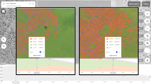
Core public and private service providers need reliable and up-to-date insights about the urban landscape in order to efficiently plan maintenance, improvement and building of infrastructure. Such data is not always easy to obtain. SpaceKnow’s proprietary algorithms deliver extensive, thorough, and reliable urban growth analysis, such as the example shown below.
Vegetation Monitoring
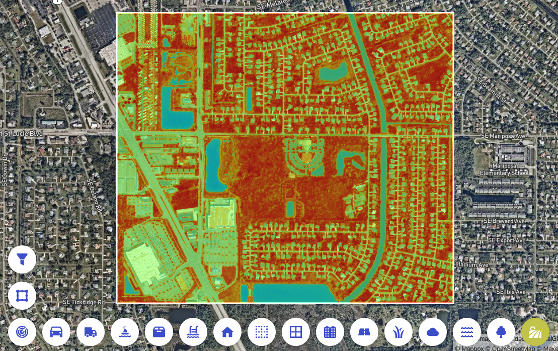
A major factor contributing to quality of life is the distribution, quantity and condition of vegetation within a city. Analyzing multi-spectral satellite images with Vegetation indices enables us to monitor the health of city vegetation across vast areas almost instantaneously.
Building Footprint Analysis
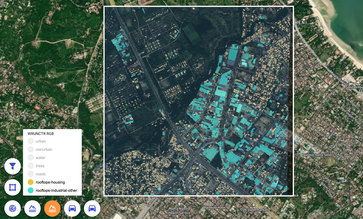
Our advanced rooftop detection algorithm recognizes individual building footprints and segments them into Residential and Commercial classes. Coupled with various post-processing algorithms, numbers and area of buildings can be analyzed, and the number of their inhabitants estimated. Urban planners and business owners can analyze the city development dynamic and incorporate it into their decision making.
Why Not Just Use Google Maps?
The past decade has seen a huge proliferation of quality orthophotos combined with online maps. Companies such as Google or Microsoft made quality satellite imaging available for all internet users, without incurring any costs. Why then, you might ask, not use freely available maps and images?
- Image relevancy. On Google Maps, time and date for an image is not specified. Impactful decisions need to be based on current and transparent data.
- Access to data. Google owns the data presented on Google Maps. It is accessible to a human eye, but not to a machine, making this data unusable for large-scale analyses.
- Spectral resolution. Images on Google Maps are presented solely in the visible spectrum, while many use-cases and applications require the analysis of wavelengths outside of the visible spectrum. Satellites can be equipped with radar, further broadening its capabilities.
- Data consistency. The quality of publicly accessible images varies widely, dependent on a given area – a city centre might be captured in high resolution, however rural areas or city outskirts may be omitted. Commercial satellite imagery enables consistent tasking of virtually any area of interest.
- Data interpretation. A person can recognize objects on an image, however to do so over extensive areas of hundreds and thousands of square kilometers requires an expert approach with experienced professionals and the use of trained AI.
Stay Light Years Ahead Of The Competition
The scope of urbanization monitoring use-cases we are able to cover is not limited solely to those described here. We push the boundaries of what is possible, and we love clever solutions – so feel free to come to us with your ideas. Transparency is of the utmost importance to us. We will always be straightforward with you, no matter if, or how we are able to solve your issues.
Unlocking the power of data from space is more accessible than ever.
Come and challenge us.