Methane has generally received less attention than carbon dioxide in the past. Things have changed dramatically since the surprising surge of global methane emissions. [1] This greenhouse gas can be considered more harmful to the climate than carbon dioxide. It is becoming evident to a broad range of stakeholders that methane mitigation is absolutely essential for the earth and sustainable human prosperity. How can satellite analytics help?
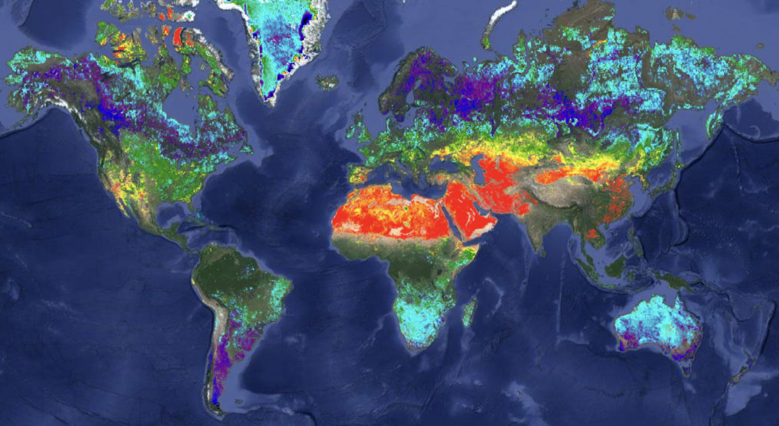
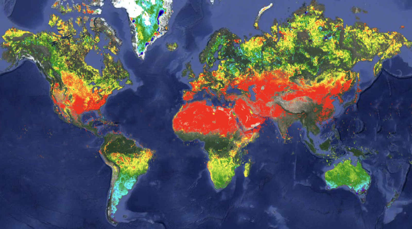
Figure 1: Global view on methane through the lenses of Sentinel 5P satellite. Comparison of September 2022 on the right with the same period in 2019 on the left side. (SpaceKnow analysis, Google Earth Engine)
Managing Methane from Space
Peter Drucker famously said: “What gets measured, gets managed.” Satellite data analytics represent a key pillar in monitoring methane emissions, especially because self-reported estimates and other kinds of data from the ground tend to be lower than values measured by scientists and analysts in the atmosphere.
Satellite imagery can serve as a great source of reliable information for:
- Confirmation of the extent of reported methane emissions.
- Detection of unreported methane emissions and leaks (under specific conditions).
- Observation of overall trends across continents, countries, or cities.
SpaceKnow Approach: Monitoring Trends and Diving into the Detail
SpaceKnow monitors and reports air pollution daily, including methane emissions, in over 600 regions and countries and adds new locations to the dataset every month. The outcome is an up-to-date set of time series for any of these monitored areas which are useful for getting a broad overview of the development of emissions across the globe.
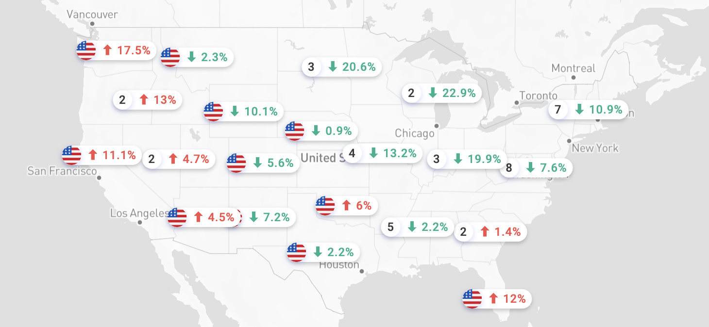
Figure 2: Near-real-time SpaceKnow monitor of overall air pollution per US state divided into specific pollutants, such as Methane, Ozone, Carbon Monoxide or Nitrogen Dioxide. Besides US states, SpaceKnow covers nearly 600 other areas. (SpaceKnow indices, contact sales for more info)
SpaceKnow places a strong emphasis also on targeted analysis of single events. The technical progress of air monitoring from space is getting better every year which enables SpaceKnow to build increasingly more precise methane-related products.
Currently, the Tip & Cue approach, an approach that combines different resolution types of satellite imagery, has proved to be efficient in localizing and describing methane leaks, as shown in Figure 3 and Figure 4 below.
First, SpaceKnow experts observe phenomena by scanning extensive areas using low-resolution satellites like Sentinel-5P (European Space Agency, 5.5km x 3.5km). Second, they investigate areas that may require special attention, ‘the tip’, using more precise sensors, such as non-visible SWIR (short-wave infrared wavelength) bands of mid-to-high resolution satellites (e.g. ESA’s Sentinel-2 with 20m resolution).
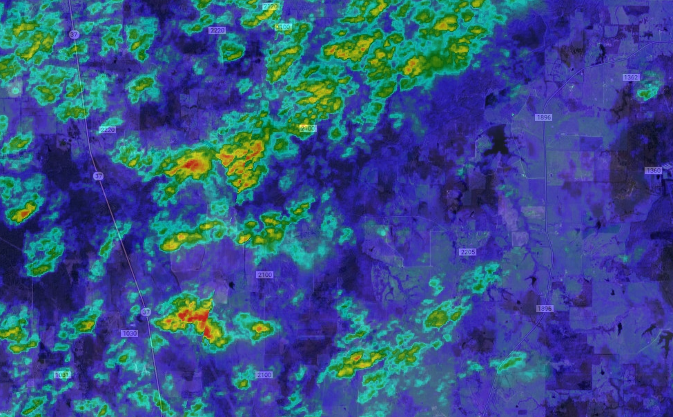
Figure 3: On the left picture, low-resolution Sentinel-5P reveals an area requiring further attention (red and orange squares). On the right side, we can observe the exact location and exact area affected by a methane leak (red and orange marks). This methane event near Mount Vernon in Texas in Dec of 2021 can be attributed to a leak in a pipeline [2]. (SpaceKnow analysis, Google Earth Engine)
The greatest advantage of this approach is the ability to get an overall picture of methane developments in a quick and inexpensive method; when needed, the client can ‘zoom in‘ and investigate specific events more precisely.
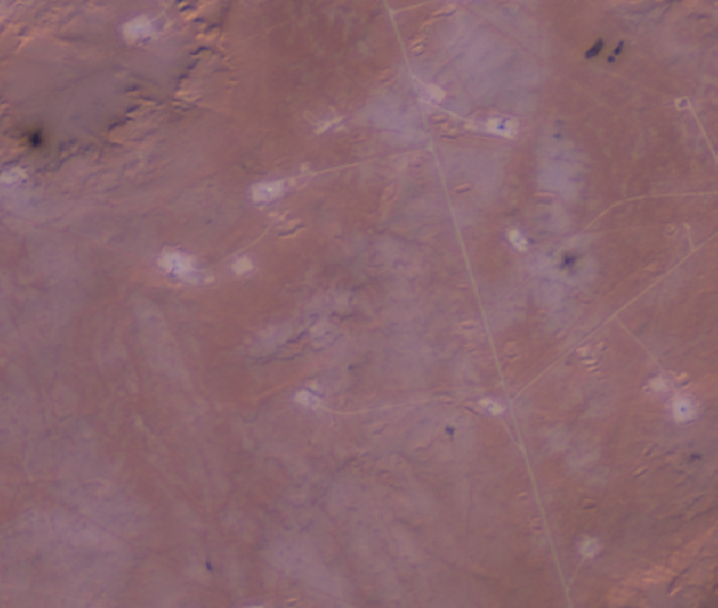
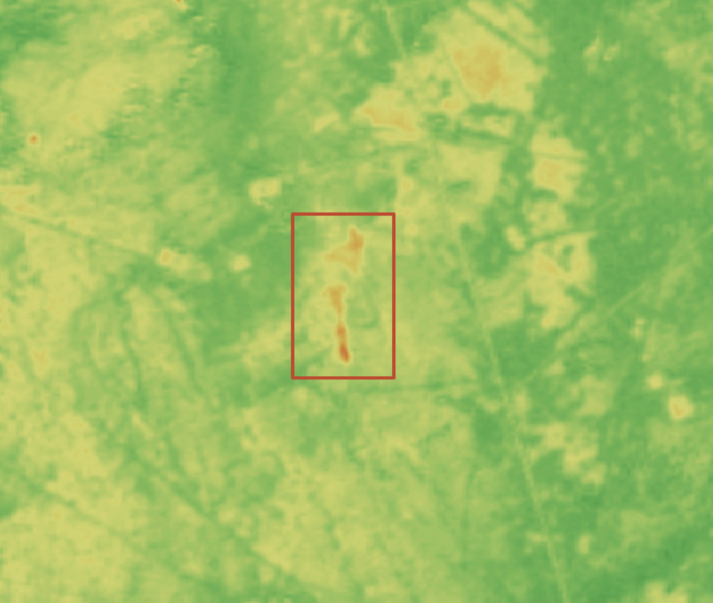
Figure 4: Detection and localization of methane leak from an oil well in Algeria, November 2019. (SpaceKnow analysis)
Concerns about Natural Sources of Methane
About half of total methane emission comes from natural sources (such as wetlands, rice fields, animals, or wildfires) and half are anthropogenic (such as fossil fuels, oil and gas or dumpsites). [3, 4]
According to experts, the world should be concerned about both factors – natural and anthropogenic – because human activities impact natural sources of methane (e.g. conditions that increase the risk of wildfires, large-scale cattle operations, or because human-originated warming of the planet creates a feedback loop of methane emissions in nature).
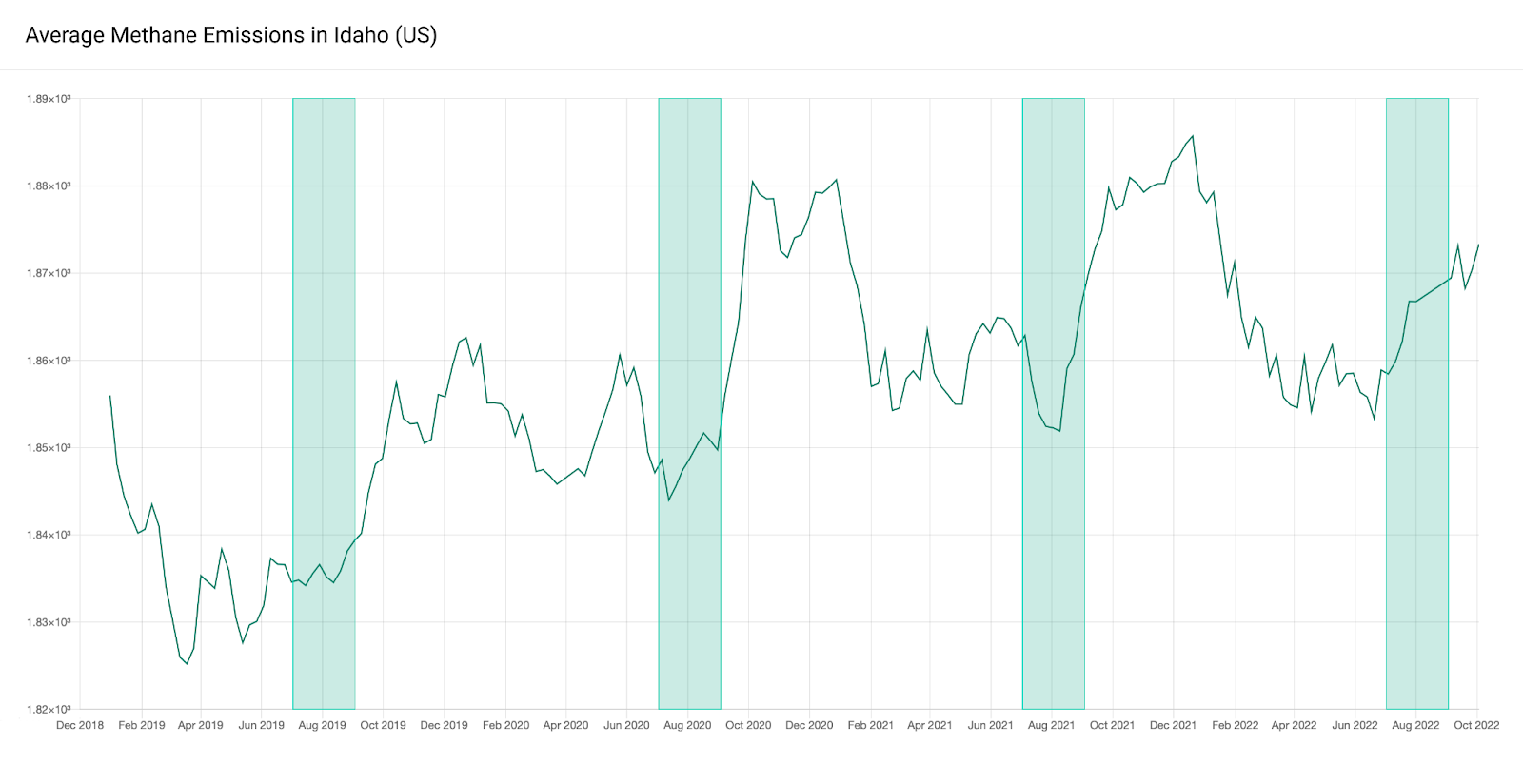
Figure 5: Methane level timelines enable year-over-year comparison of methane levels during seasons of interest. In this graph “Methane emissions in Idaho (US)”, the seasonal methane peak is rising earlier in 2022 than in previous years which can be partly explained by major wildfires. [5] (SpaceKnow)
One course of study focuses on the different natural sources of methane and their emissions. Satellite-based analytics can provide insights into this study by automated, scaled and near-real-time analysis of emissions over wetlands, cattle, rice fields, landfills, or forests after wildfires.
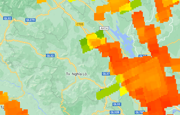
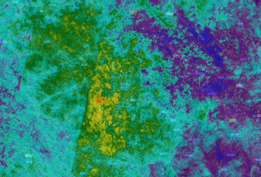
Figure 6: Methane emissions in the northeast region of Vietnam are likely connected to the extensive rice field operations in the region. The picture on the left shows methane observed by the low-resolution Sentinel-5P satellite. The image on the right reveals a more detailed view of the same area leveraging the benefits of short-wave infrared sensors. (SpaceKnow analysis, Google Earth Engine)
How Can SpaceKnow Help Your Organization?
Climate change is one of the most critical challenges humanity faces today with methane being a key driver. Whether your organization is searching for automated monitoring and alerting services on emission trends or an investigative tailor-made solution, SpaceKnow is here to help.
Satellite-based analytics can provide valuable insights and scaled solutions to tackle emissions as well as other climate-related issues. Using insights from space to complement traditional data sources, SpaceKnow can do the following:
- Scan over extensive areas and provide a cost-efficient scaled solution.
- Provide unbiased ‘raw’ data from space that are free of human bias.
- Capability to measure what is normally hidden from the human eye by employing a broad range of sensors in the visible and non-visible parts of the spectrum.
In addition to emissions monitoring, SpaceKnow is currently improving its technology to monitor carbon sinks, deforestation and reforestation, vegetation health, drought evaluations, floods, and other environmental events.
SpaceKnow’s capabilities bring confidence and reduce risk to operations and investments around the world. Interested in learning more about SpaceKnow and its services? Reach out to info@spaceknow.com